Intersection improvements at Punkeydoodles Corners to begin week of July 29
Road 101A and section of Perth Road 101/Oxford Road 24 to close with detours provided east and west

 Construction to improve road safety at Punkeydoodles Corners begins the week of July 29, acting on a number of recommendations put forward in a joint intersection control feasibility study undertaken by Oxford County, Perth County, Township of Wilmot and Region of Waterloo last fall.
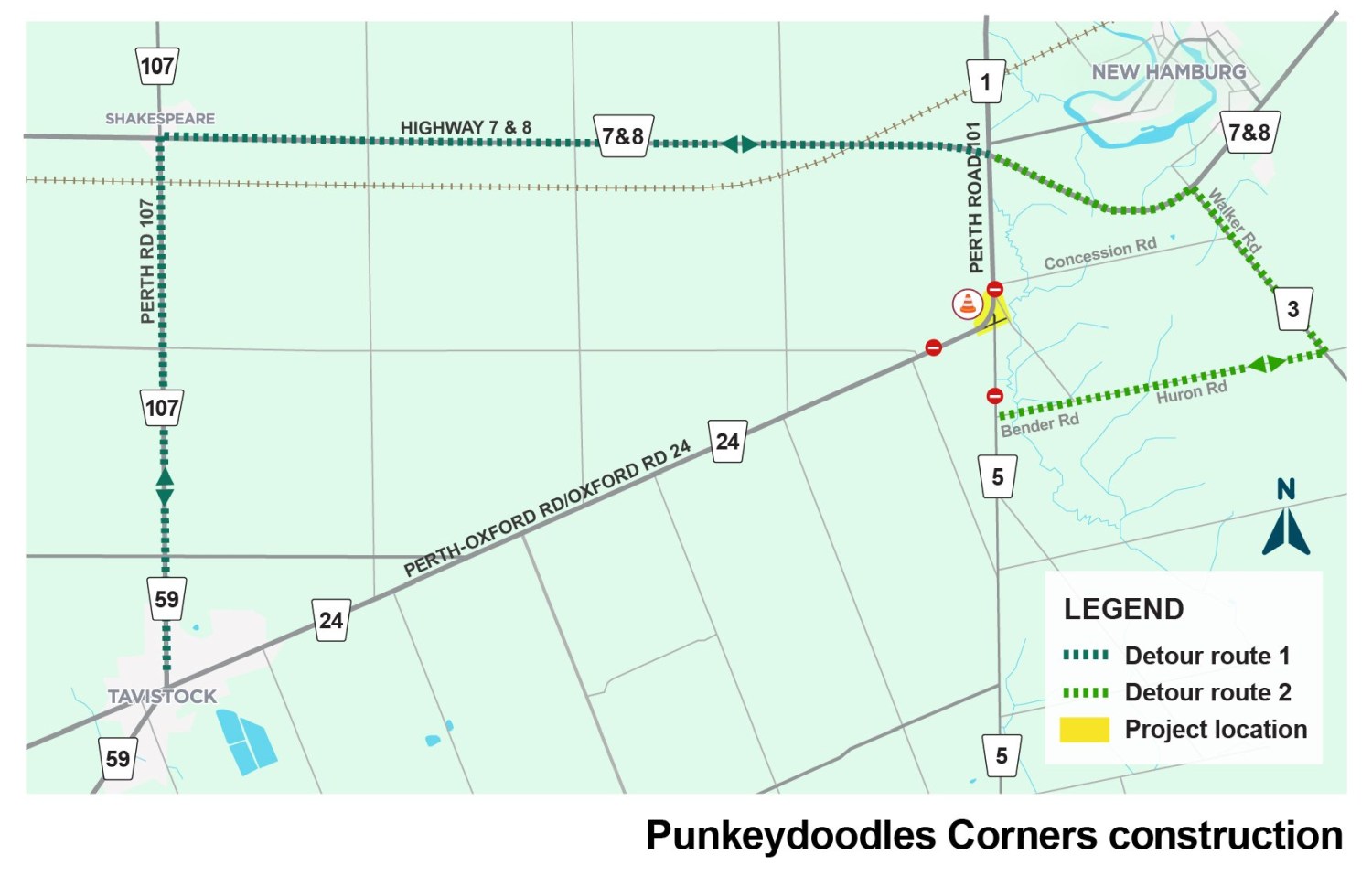
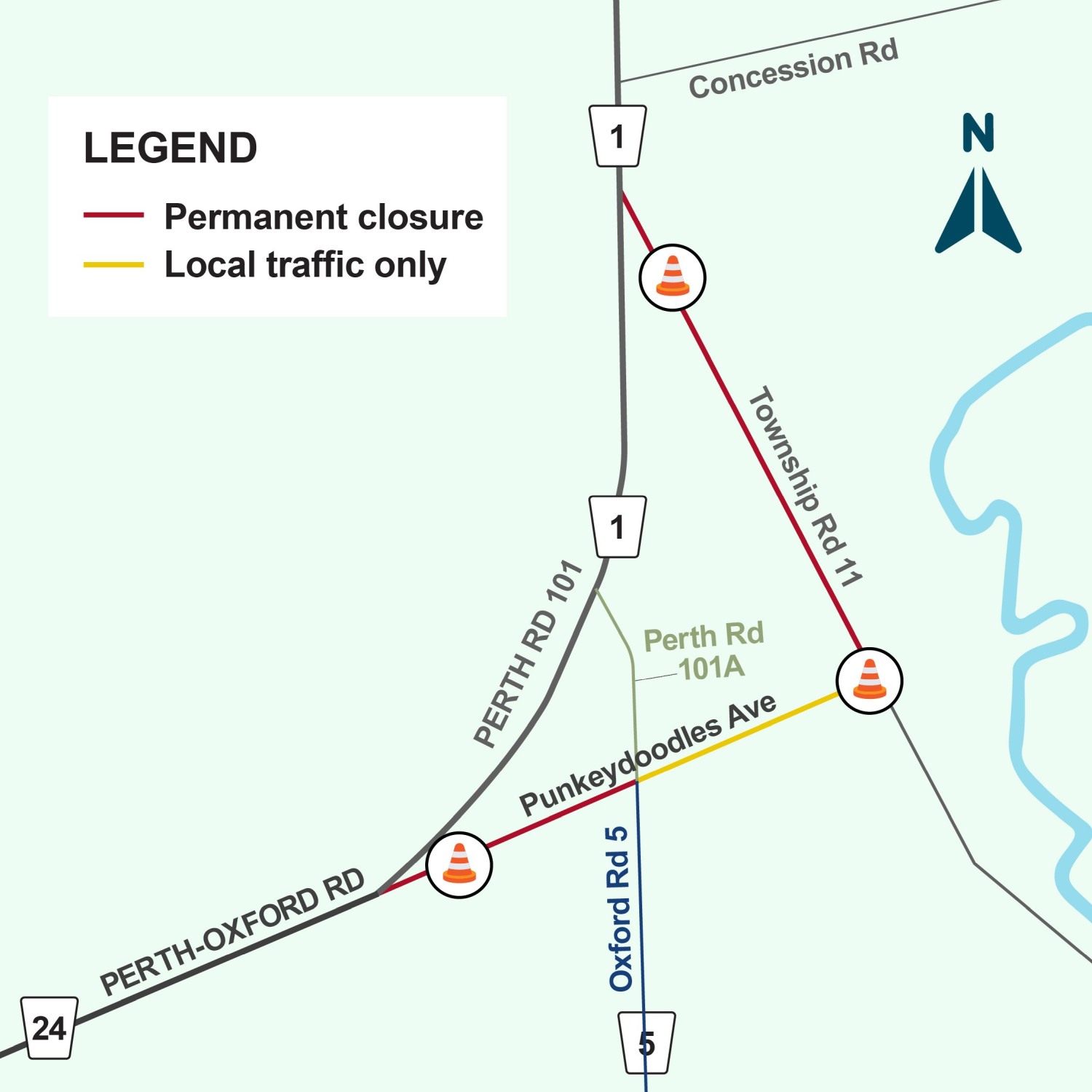
During construction, Road 101A and Perth Road 101 (Oxford Road 24) east of Line 33 to Concession Road will be closed to all through traffic, with access limited to local residents, businesses and emergency services only.
Two detour routes are in place during construction:
- Eastbound detour route: Huron Road/Bender Road, Walker Road, and Highway 7 and 8
- Westbound detour route: Perth Road 107 and Highway 7 and 8
Construction is expected to finish in November 2024, although timing is subject to weather and other factors. Following construction, the west leg of Punkeydoodles Avenue at Perth Road 101 and the north leg of Township Road 11 at the intersection of Township Road 11 and Perth Road 101 will remain permanently closed.
Road safety improvements at Punkeydoodles Corners include a reconfiguration of the current intersections, pavement reconstruction, deceleration lanes, additional street lighting and enhanced signage. Recommendations from the intersection study followed extensive feedback from the community about safety concerns.
For more information visit www.speakup.oxfordcounty.ca/punkeydoodles.
Quick facts
- The Punkeydoodles Corners area is made up of four intersections that are shared among the municipalities of Oxford County, Perth County, Township of Wilmot, and Region of Waterloo:
Punkeydoodles Avenue and Oxford Road 5
Perth Road 101 and Road 101A
Perth-Oxford Road/Oxford Road 24 and Perth Road 101
Perth Road 101 and Township Road 11
- In June, Oxford County Council awarded a $1.08 million construction contract for intersection improvements at Punkeydoodles Corners to Capital Paving Inc. The construction project is being led by Oxford County and jointly funded by partner municipalities.
- The Punkeydoodles Corners Intersection Control Feasibility Study released in October 2023 considered community input and existing traffic data, such as traffic volumes, traffic patterns, collision history, operating speeds, and sight lines, and projected future traffic conditions over the next 20 years.
Graphic
Detailed map: Construction area and detour routes for Punkeydoodles Corners (July 2024)
About Oxford County
Located in southwestern Ontario at the crossroads of Highways 401 and 403, Oxford County has a population of approximately 135,000 people across eight area municipalities that are “growing stronger together.” A partnership-oriented, two-tier municipal government, Oxford County is committed to 100% renewable energy, zero waste, zero poverty, and being 100% housed. Oxford County is situated in one of Ontario’s richest areas for farmland, with a diversified local economy that is home to an innovative agricultural industry, leading automotive manufacturers, and the Oxford County Cheese Trail. Oxford also offers a thriving local arts and culinary community, as well as conservation parks, natural areas and more than 100 kilometres of scenic trails. The County’s Strategic Plan puts forward a vision of “Working together for a healthy, vibrant, and sustainable future.” The Oxford County Administration Building is in Woodstock, Ontario. Visit www.oxfordcounty.ca, follow us on social media, or download our Facts and Stats to learn more.
